Rising Challenge
After Battle With Erosion on Hatteras Island, Critical Road Rerouted Over Causeway

Highway to Hatteras will cross a causeway for protection.
PHOTO BY FLATIRON CONSTRUCTION INC.
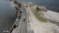
 Maintaining Route 12, the main highway serving the barrier island of Hatteras Island, N.C., is a near-constant battle against the elements. Now, instead of continuing the battle, the state has decided to move the road.
“Closure of Route 12 even for a day or two is not desirable for those who live on Hatteras Island and rely on the highway to provide access for tourists, the largest drivers of its economy,” explains Pablo Hernandez, NCDOT district engineer. “It’s also their only access to the hospital and other medical facilities, jobs, and other off-island activities.”
One area, called the “S-curves” within a federal wildlife refuge just outside the village of Rodanthe, is eroding at a rate of approximately 12 ft per year, according to the agency’s monitoring data. Between 2011 and 2016, North Carolina spent nearly $31 million to repair and restore the S-curves. That figure includes $20.3 million for Corps of Engineers-designed emergency beach nourishment, which will protect the road and prevent daily wave action from undermining a sandbag dune originally placed 2009 and rebuilt several times since.
Those efforts are going to become even more problematic with rising sea levels that are projected to increase as much as a quarter inch per year. Rather than continuing to fight Mother Nature, Route 12 will be rerouted via a jug-handle-shaped back-barrier causeway (see rendering above) rejoining the highway at a more stable location in Rodanthe. The new route also is part of a settlement in a long-running dispute with environmental groups that had delayed construction of a new Oregon Inlet bridge at Hatteras Island’s north end.
Scheduled to begin in January 2018, the $145.33-million design-build causeway project is being led by Flatiron Construction. The new structure, scheduled to be complete in 2020, is being designed for a 100-year life span.


