| + click to view a map of ongoing work | |
 |
The Jobsite: 169 Miles of Damage Repair |
June 1 is Judgment Day for the U.S. Army Corps of Engineers. That's when the world's most powerful organization of civil engineers has pledged to deliver on its promise to restore the hurricane protections defeated last fall when Hurricane Katrina inundated an estimated 151 sq miles of New Orleans and neighboring parishes.
 |
 |
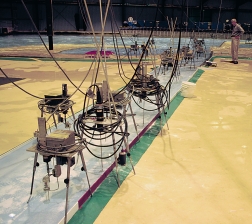
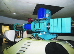
| Models. Corps' mock-up of New Orleans 17th Street Canal and lakefront fills a hanger above, while sample of its levee gets ready for a twirl, below.(Photos by Tom Sawyer for ENR) |
The Corps will deliver, "but a lot of work is going to go on beyond that date as we continue to make the system better," says Col. Lewis Setliff,commander of the Corps' Memphis District. Setliff heads Task Force Guardian, a strike team gathered from around the Corps to manage the effort to rebuild the system in 10 months to be as good, or better, than it was when Katrina ripped through it, on Aug. 29, 2005.
The worksite is enormous. Thirty-three construction firms with 59 contracts are scrambling to repair 169 miles of breaches, scour and destruction scattered like bomb craters across the 350-mile-long system. The contracts are worth $428.4 million, but with the additional costs thrown in, including securing real estate, supplied services, technical review, audits, and 5.5 million cu yd of high-quality clay for levee repairs, the total cost hits $1 billion.
"It has been pretty much seven days a week since we started in September," says Setliff. A lot of the jobs run around the clock. "We've had two official days off—Thanksgiving and Christmas," he says.
Much of the work of raising levee elevations is an "acceleration to completion" of projects planned around federal funding cycles at a 35% local, 65% federal split through 2017. But now it is all going off at once with 100% federal money under flood control and construction emergency funding, says Col. Richard P. Wagenaar, district commander for New Orleans. In normal times a typical project may take years to plan, resolve real estate and environmental issues, design, bid and build, he says. Under the emergency, all of the work is being compressed into months, everywhere at once.
 |
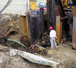
| Challenge. Workers wrestle steel and concrete in solitude and mud in race against time.(Photo by Michael Goodman for ENR) |
"For each parish we put together a multifunctional team," says Setliff. "We had real estate people, environmental people and structural and civil engineers. Each team has a leader who can make decisions very quickly...the schedule here is of paramount importance." He says that while management has been "intensive," the philosophy is to treat contractors like partners, track their progress closely, monitor constantly and meet frequently, but only "manage by exception—if they start to get off track."
"Our philosophy early on was that we wanted to ensure victory back in February, instead of prevent defeat in May. Probably when people look back at this it will be seen as the wave of the future," Setliff says
"None of these jobs has worked out the way any of us expected—labor, equipment, so many unknowns," says Wayne Ledet, one of the owners of LL&G Construction, Houma, La., in his job trailer at the Bayou Bienvenue Flood Control Structure repair site. James Drinkwater, one of Ledet's superintendents on another flood control repair, says maintaining a labor force to keep pace with the schedule is his biggest challenge. "I could use five more welders today, but I can't get them," he says.
Everything is at a premium. "We had to stockpile material in order to have enough," adds Ledet. "That's one thing I told the Corps: ÔYou've got to allow us to stockpile if we're going to get this job done.'" Plugging the 310 ft of breaches at Bayou Bienvenue took 40,000 tons of rock, 50,000 yd of sand and 8,000 yd of clay. "Clay before the storm was $15 to $25 per yard; now it's $45," Ledet says.
Ledet strongly supports the Corps' approach to the work. He says he has built flood control structures and pump stations for 15 years for both the Corps and local governments. Despite the widespread failures throughout the system, he still feels consolidating all levee construction, operation and maintenance under the Corps is the only way to go. "Locals don't understand compaction and quality control," Ledet says. "If they take the levee work from the Corps...it will be all about locals and buddies."
Construction innovations are driven by rapidly improving understanding of the engineering requirements for building survivable hurricane resistant systems. A $20-million, crash research campaign has been under way since the storm, also under sponsorship and direction of the Corps and centered around its Engineering Research and Development Center in Vicksburg, Miss.
 |
 |
| Not Even Close. Hours of overwash in St. Bernard Parish, top, floated vessels over walls, ripped out holes and left levee-top gas lines in the air,bottom.(Top photo courtesy of USACE, bottom photo by Tom Sawyer for ENR) |
Called the Interagency Performance Evaluation Review Taskforce, the project has pulled together a team of 150 scientists and engineers who are analyzing the storm and the behavior of the flood protection system during it. Their preliminary results are leading to significant changes in design and construction.
"It's a high performance team," says the task force's technical director, John J. Jaeger. Half of the project leaders, including Jaeger, are drawn from experts within the Corps, and half from federal agencies or academia.
They are trying to answer questions about how the system's many structures were designed and built, and what condition they were in when Katrina came ashore. The storm, with its winds, waves and surge, has been modeled with three separate programs on a Cray XT3 supercomputer with 256 parallel processors, using meteorological data from the National Hurricane Center and other sources. The model covers the entire region and is based on 377,815 data points solved in one-second time steps, over six days. It takes 75 minutes for the Cray to run the storm, says Bruce Ebersole,chief of the ERDC flood and storm protection division.
Ebersole says factors in the height of the surge were wind speed and direction and the shape of the land masses and sea bottom. The computer models show how those variables morphed with the movement and changing intensity of the storm, and reveal how serious the set-up for disaster was. "Katrina's winds traveled across the continental shelf and ran against the large bays, piling up the water well ahead of the storm," says Ebersole. "A day-and-a-half out, the water was already up three or four feet. The wetlands were inundated."
 |
| Analysis. Resio investigates wave forces on floodwalls.(Photo by Tom Sawyer for ENR) |
Wave behavior also changed dramatically as the storm neared land. The model has raised eyebrows by demonstrating how long-period waves, "which convey a lot more energy at a given point and can give a 75% greater run-up," began to pile up against the levees lining the Mississippi River Gulf Outlet to the east of the city, he says.
"This is the most rigorous analysis for hurricane winds [the National Oceanic and Atmospheric Administration] has ever done," Ebersole says. Engineers have gone into the field to retrieve hard evidence such as eyewitness accounts, photographs, stopped clocks, and carefully surveyed high-water marks. By combining those data points with the computer model they have created what they believe is a 95% accurate simulation of how the storm created the surge that sank New Orleans.
Better, more survivable instrumentation would help but there are few that can survive a hurricane, Ebersole says.
Almost every instrument in Katrina's path failed before the storm peaked at each location. One of NOAA's 10-meter-dia, saucer-shaped instrument buoys flipped, although another buoy, well offshore in 900 ft of water, reported a maximum wave height of 55 ft. Ebersole says that is the highest ever reported on the U.S. Continental Shelf. Maximum wave height is an average of the highest 13 waves.
|
Surge modeling has predicted phenomenon that correlates closely with data investigators have gleaned from the wreckage of New Orleans. The findings are analyzed and applied as force data to study the performance of the engineered protections when assaulted by those loads.
In February, members of the team working at Rensselaer Polytechnic Institute used the data on a 50:1 scale model of the portion of the 17th Street Canal levee and I-Wall-style floodwall, whose collapse initiated massive flooding of the north side of New Orleans. The model duplicates, at scale, the materials and properties of the structure. Since gravity cannot be scaled in the same way, the model is then encased in a strong, aquarium-like box and swung on a centrifuge to add weight before flood waters flow in.
