A magnitude 7.1 earthquake struck Southern California at 8:19 p.m. Friday with an epicenter 11 miles from Ridgecrest, Calif., a city that sits in the southern Indian Wells Valley and the northeast corner of Kern County. The earthquake, the largest in two decades, followed a 6.4 foreshock that struck the same area a day earlier.
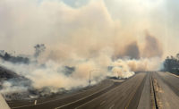
On Sunday, the California Department of Transportation (Caltrans) said permanent construction repairs were started on State Route 178 (SR 178), about six miles east of Ridgecrest, where the highway cracked in three separate areas within four miles. Caltrans said in a press release that Bob Franzoia, interim director of Caltrans, signed an emergency order allocating $3.1 million the SR-178 repairs and that Sully-Miller Contracting Company has been contracted for the work.
On Friday, prior to the 7.1-maginitude earthquake, the five bridges in the area were reported to have minimal to no damage, with ongoing inspections by bridge engineers.
According to the U.S. Geological Survey (USGS), Thursday's earthquake was at a depth of 10.7 km or 6.65 miles. Friday night's earthquake, which came approximately 34 hours after and 11 km northwest of Thursday's foreshock, occurred at a depth of 8 km or 4.97 miles as a result of shallow strike slip faulting in the North America plate crust and indicates a rupture on a steeply dipping fault, "as the result of either right lateral slip on a plane striking NW-SE, or as left lateral slip on a plane striking SW-NE."
According the USGS earthquake forecast, a 2% chance of one or more aftershocks larger than magnitude 7.1 remains in effect for one week from the July 6 temblor.
"It is likely that there will be smaller earthquakes over the next one week, with 220 to 330 magnitude 3 or higher aftershocks. Magnitude 3 and above are large enough to be felt near the epicenter," said USGS in a press release. "The number of aftershocks will drop off over time, but a large aftershock can increase the numbers again, temporarily."
The USGS, the California Geological Survey, and the U.S. Navy - have begun to survey and map surface ruptures and offset features resulting from the earthquake and will release investigation results to the public in the coming weeks.
Lucy Jones, a research associate at the Seismological Laboratory of Caltech, had warned the public at a press conference in Pasadena on Thursday that the odds of an earthquake greater than a magnitude 5.0 was bigger than 50/50. Jones confirmed that Caltech’s newly-launched Seismological Laboratory ShakeAlert, an earthquake early warning system, registered Thursday's and Friday's earthquakes but did not trigger a warning message to the public because the app estimated that shaking would not damage Los Angeles County, the area ShakeAlertLA app covers.
On Thursday, the City of Los Angeles said in a tweet that the ShakeAlert app only sends alerts if the shaking is greater than 5.0 in Los Angeles County. “Epicenter was 6.4 in Kern County, @USGS confirms LA’s shaking was below 4.5,” @LACity said in a tweet. “We hear you and will lower the alert threshold with @USGS_ShakeAlert.”
Sally Jeun, spokesperson for Southern California Edison, said that as of Friday morning, power was fully restored to 6,500 customers affected by outage due to Thursday's earthquake. Jeun said the power disruptions were caused by circuit relays, and the infrastructure sustained no major damage.


