Environment
California OKs Dam Releases as Storms Raise Reservoir Water Levels
A pair of severe rain events have caused widespread flooding across California and the West Coast over the past week and forecasters are calling for more to hit the state later this month.
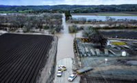
According to Jeremy Arrich, manager at the California Dept. of Water Resources Division of Flood Management, ten rivers across the state exceeded flood stage during the latest round of storms. In the most severe event, the Pajaro River levee breached late on March 10. The approximately 2,000 residents of the community of Pajaro were evacuated as floodwaters inundated the area. Crews with the California Office of Emergency Services and the County of Monterey were able to fill the damaged levee on March 14.
“The crews out there will continue working to raise that filled break with material to bring that levee break back to the surrounding levee height,” Arrich said.
President Joe Biden issued an emergency declaration for California authorizing FEMA to coordinate all disaster relief efforts in 34 of the state's 58 counties. Gov. Gavin Newsom (D) proclaimed a state of emergency to support storm response and relief efforts in 43 counties.
In addition, two FEMA Incident Management Assistance Teams are on the ground supporting the California Emergency Operations Center and managing an incident support base for staging supplies. The U.S. Army Corps of Engineers is delivering sandbags, while Urban Search and Rescue teams remain on standby to support if needed.
Additional atmospheric river rain events are expected through the end of March, said Michael Anderson, state climatologist.
From late December through mid-January there were approximately nine major storm systems that swept through the state. These events, known as "atmospheric rivers," raised water levels for many state reservoirs, returning them close to normal levels.
To maintain those levels as runoff from the most recent pair of storms moved through the system, the Dept. of Water Resources authorized releases from several dams including those at Lake Oroville and Lake Folsom starting on March 10. Since Dec. 1, Lake Oroville has gained approximately 193 ft in elevation and 1.86 million acre-feet of water, according to department officials.
The Oroville Dam release on March 10 marked the second time the main spillway has been utilized since being rebuilt in 2018. The structure suffered major damage from erosion when it was opened after heavy rainfall in 2017. A 1,100-ft-long, 200-ft-deep trench was gouged in the main spillway and more than 200,000 people living downstream were evacuated for fear of catastrophic flooding.
A $500-million project to build a new, reinforced spillway with extensive monitoring systems was completed by Kiewit in November 2018. The rebuild restored the spillway to its original design capacity of 270,000 cu ft per second.


