Fla. Researchers Probe 'Mother of All Sinkholes'

Sinkhole swallowed up two houses following its appearance on July 14. Florida researchers are seeking more information on the cavity’s appetite for destruction.
PHOTO BY LUIS SANTANA/TAMPA BAY TIMES VIA AP

Pasco County Emergency Management tagged for demolition more houses near the sinkhole.
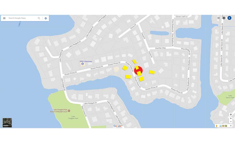
PHOTO ORIGINAL MAP DATA ©2017 GOOGLE


It will take months to complete remediation of the largest sinkhole in Pasco County, Fla.’s recent history, county officials say. Seven houses have been lost or condemned since the sinkhole was reported at 7:21 a.m. on July 14. That day, two houses collapsed into the hole, which initially measured 225 ft long and 50 ft deep. As the cavity’s dimensions grew to between 260 ft and 180 ft, the county red-tagged five additional houses.
On July 31, the county awarded a $640,000 contract to Ceres Environmental Services, Sarasota, to remove debris and stabilize the sinkhole. The county estimated the total initial cost of the sinkhole, including fill, other services and fees, at $1.3 million. Earlier, Intertek PSI received an estimated $50,000 contract to test the structural integrity of the streets and easements that will be traveled by trucks and heavy equipment to access the site.
For two weeks, a parade of trucks delivered more than 13,600 cu yd of uncrushed lime rock to stabilize the banks of the hole. On Aug. 7, Ceres revised its estimate to $1 million. On Aug. 14, the contractor completed debris and water removal and began demobilization.
Preliminary estimates were that as much as 135,000 cu yd of material would be needed to fill the sinkhole. “In 30 years, this is the largest sinkhole we’ve had in Pasco County,” said Kevin Guthrie, assistant county administrator for public safety. At a future date, the Board of County Commissioners will decide on the next phase of work, a spokesman says.
Now, research teams from the University of South Florida School of Geosciences are mapping and modeling the sinkhole, which occurred in a Land O’Lakes subdivision called Lake Padgett. A Florida Geological Survey map places the site in Area III, an extensive area in which “cover-collapse sinkholes dominate” and “develop abruptly,” FGS says. While this kind of sinkhole is infrequent, “when they do happen, they happen so rapidly that, a lot of time, we’re not able to get a real-time understanding of processes,” says Lori Collins, geosciences professor and co-director of the USF Library’s Digital Heritage and Humanities Collections.
Having grown up near the site of this sinkhole, Collins now leads a team that is 3D-modeling the surface of the sink area with terrestrial laser scanning. Aerial drones are being used to see the connections among the lake systems “because all this is … holistic,” she says. Another geosciences team is doing ground-penetrating radar surveys of the sink area and nearby. “We’ve been tying all that in with the control that we have. That way, we can consider all of this in relation with our surface model,” Collins says.
Laying a 1999 map over an 1847 map reveals a hint about the origin of this sinkhole. In a radio interview, Collins explained that the area’s lakes have been altered, possibly by construction up to 50 years ago, to increase the lakefront property for the Lake Padgett development. Where the sinkhole occurred was lake bed before. “By today’s standards, I think this development would have happened a lot differently,” Collins said. “So, this is something that Pasco will need to consider and look at because, essentially, what [the data are] telling me is that this lake is trying to go back to what it once was.”
Extensive areas of Florida are vulnerable to sinkholes because limestone underlies so much of the state. While most Florida jurisdictions require a geotechnical study for only commercial property, a Pasco County ordinance requires for all development plans a geotechnical engineering report on the property proposed for development. The ordinance was adopted in 2008 and is not retroactive.


