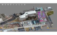
In Coatesville, Pa., a depressed, rust-belt town about 40 miles west of Philadelphia with a population of 13,100, the city manager and the town’s consulting engineers are using 3D reality capture to help prospective developers see a diamond in the rough.
April Barkasi, founder and president of Cedarville Engineering Group LLC, Pottstown, came up with the idea of using Bentley System’s ContextCapture to build a 3D digital terrain model of a brownfield site as the basis for a redevelopment concept plan.
In just a few minutes, a drone captured more than 750 aerial photos of “The Flats,” a rugged, 30-acre former steel-mill site. The ContextCapture software processed the drone’s photos, combining them with old survey data and other photos to create a detailed model of the site—all without anyone having to set foot on it. The model includes a significant amount of stockpiled clean fill, which is a sweetener for any redevelopment deal.
|
Related Link |
“We wanted to generate topographic data as efficiently as we could for this ‘environmental justice’ community,” Barkasi says, citing a state Dept. of Environmental Protection program that provides extra assistance to communities whose population is at least 20% below the poverty level or at least 30% minority. “They have a real socioeconomic need for new infrastructure. As civil engineers, we look for as many creative ways as we can to squeeze more dollars out of the budget,” Barkasi says.
The Coatesville Redevelopment Authority is tasked with returning the site to productive, taxable use. But, first, it needs to attract a developer. “We’re a pretty depressed city,” says city manager Michael Trio. “We’re trying to come back.”
To start this process, Trio says the city needs to document what it has and then present conceptual plans to show the kinds of reuse envisioned. Speaking of the model, he says, “From the standpoint of seeing the topography and seeing how the project fits into the area and the ideas we have for the site, it’s been really useful,” adding, “This makes it much easier for the private sector to come in and see what we have. This is a great foundation.
“Like any government agency and municipality, we have a planning commission and boards that are mostly made up of lay people. This visual technology makes it so much easier to communicate. It gets buy-in,” Trio says.
The tract would be expensive to survey conventionally, says Barkasi. The site contains foundations from the steel plant as well as hazardous materials. It also requires special procedures and permits to enter. Further, the site is bounded by easements for active railroad tracks and highways, a floodplain, and a creek—all of which would require separate permissions. “It could be a $40,000 effort to get a traditional survey,” Barkasi says.
But in this case, a drone, a camera, four perimeter ground-control points and ContextCapture resolved the puzzle in a few hours. “There’s parts of the property that are very difficult to access,” says Trio. “This technology makes it almost like having boots on the ground—without having boots on the ground.”
Barkasi says the modeling was done as a service to the city without special compensation. “We are the city’s engineers,” she says. Otherwise, the firm would have charged $8,000 for the work, she says, noting that the cost of similar work for another site would need to be assessed separately for its requirements.
Through the modeling, the engineers calculate the stockpiles hold about 22,400 cu yd of fill. Barkasi says this demonstrates that there is already enough stockpiled material on the site to cap—that is, place two feet of fill—over seven acres of the 26 acres within the city boundary. This amount exceeds the required “open space” zoning provisions approved for the parcel. “Bulk clean fill ranges in value from $8 to $20 per cubic yard, [which] represents a huge cost benefit,” Barkasi says.


